Whether or not Napoleon was a keen walker is not fully documented (he was certainly no stranger to a long march). What we do know, however, is that he decided that the French coastline was part of the nation’s heritage and so gave all citizens the right to access it.
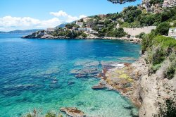
Sentier du littoral near Ville de Cap d'Ail
In 1976 the Sentier du Littoral (coastal path) was formally created on a national scale with an unbroken three-metre strip along the entire length of France’s coast.
Along with France’s magnificent Grande Randonnée network of long-distance footpaths, it forms a vast network from the GR21 on the Alabaster Coast in the north to the GR51 on the south coast, linking Marseille to Menton on the Italian border.
Today there is no single unbroken path, largely due to urban sprawl and factors which were not present in Napoleon’s time (not least naturist campsites and high-end housing). In some areas, the land is now privately owned but with public rights of way across it.
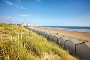
There are some 5,000 km of designated coastal paths, mostly accessible and relatively straightforward terrain. Some stretches are more challenging; in fact, in places, you should be very careful indeed, such is the precarious nature of the terrain and ground underfoot. Wherever you are, you will need appropriate clothing, sun protection when hot and plenty of water.
The pleasures of walking the coast
Walking has many obvious appeals – constantly changing scenery, a sense of purpose and gentle exercise (helps you feel just a little virtuous when perusing the evening menu later!).
Following a coastal path adds other dimensions: sweeping seascapes, coastal terrain of various types and bracing sea air.
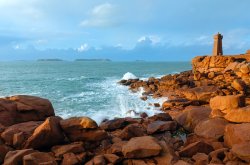
Granite Rose Brittany
Brittany is renowned for its ancient smuggler’s paths. Around Concarneau, you can trace the steps of many a shipwrecking scoundrel and imagine the customs officers in hot pursuit. You’ll come across massive boulders, gorse and rocky outcrops, not to mention the mesmerising pink granite of the Pink Granite Coast, which runs along the north coast.
France’s west coast is an endless sandy beach, stretching roughly from Nantes to Biarritz, backed by fragrant and shady pine forests. When the going gets hot and sticky, these paths allow the indulgence of a quick splash in the gently shelving waters of the Charentais or the Landes beaches.
The Mediterranean coast is different again. Twisting paths in many places is challenging, with gnarled trees clinging onto sheer cliffs, and rocks below pounded by the surf.
But the azure blue waters of the Med and the scintillating light of Provence combine to create something magical. It is no accident that so many artists have sought inspiration here: Picasso, Van Gogh, Miró, Matisse and many others. Perhaps they were also keen walkers?
Frances Coastal Paths
Sorry, this map cannot be displayed.
The following consent is required: Tracking & performance, Targeting & advertising.
GR120 - Bray-Dunes to Le Tréport From - Bray-Dunes To - Le Tréport Trail Length - 292 km Maximum Elevation - 141 m Total Climb - 635 m
GR21 - Sentier des Falaises From - Le Havre To - Le Tréport Trail Length - 187 km Max Elevation - 130 m Total Climb - 2,703 m
GR223 - Littoral de la Normandie From - Honfleur To - Mont St Michel Trail Length - 612 km Maximum Elevation - 149 m Total Climb - 3,931 m
GR34 - Sentier des Douaniers From - Mont Saint Michel To - Saint Nazaire Trail Length - 2,101 km Maximum Elevation - 106 m Total Climb - 7,957 m
GR8 - Atlantic Coastal Path * From - Saint-Brevin-les-Pins To - Sare Trail Length - 600 km Maximum Elevation - 175 m Total Climb - 2,000 m
GR51 - Balcon de la Méditerranée From - Menton To - La Madrague Trail Length - 436 km Maximum Elevation - 1,073 m Total Climb - 13,880 m
* The GR8 route is the newest in France, and as such, the route is yet to be finalised; distances and elevations provided are approximate.
If you're looking for walking maps for any of the above routes, then why not head to the Alan Rogers Shop, where we have a wide range of IGN maps available?
Author
Rob Fearn
Editor - Alan Rogers Guides
Rob has been involved in the leisure industry since completing a BTEC in Travel & Tourism in 1993. Previous roles have included the promotion of tourism in Yorkshire and running a motorcycle touring company in the Australian Outback.
He is the General Manager at Alan Rogers Travel Group, responsible for the ongoing development of the Alan Rogers website and the publication of the Alan Rogers Guides and 'Destinations' magazine.
Rob has owned several caravans, and he regularly travels with his wife and young daughter in their VW Transporter, complete with a Tentbox roof tent. A keen cycling fan, Rob can often be found in a field in Belgium during the 'Spring Classics' season.
The glittering Côte d’Azur entrances and lures people from afar – lovers of the life of luxury and the froth of the international jet set come here. But so too do those in search of modern campsites, convenient golden beaches and endless sunny days.
From south of Nantes, down to the Gironde estuary, runs a flat, sparsely populated and rather unprepossessing region which draws in more holidaymakers than any other département on France’s Atlantic coast.