Plymouth has played a crucial role as a military city, deeply influenced by war and conflict. This guide explores the landmarks, memorials, and attractions that make up Plymouth's identity and are a cherished destination for both locals and visitors.
The Hoe
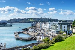
Plymouth Hoe stands as a testament to the rich history and cultural heritage of Plymouth, a city shaped by its military past and maritime significance. This iconic area, once restricted military land, has evolved into a vibrant civic space that honours historical events and figures while offering stunning views and recreational opportunities.
From medieval settlers to Victorian art deco developments, and from heroic naval battles to modern memorials, the Hoe encapsulates centuries of Plymouth's story.
History of the Hoe
The Hoe dates back to medieval times, long before Sir Francis Drake famously played bowls in 1588 while waiting for the Spanish Armada. Walking around the Hoe, it's easy to see why the Victorians cherished the views and developed the park in the 1870s.
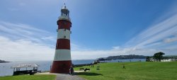
The landmark lighthouse, built by John Smeaton to guard the Eddystone Reef, was relocated to the Hoe in 1882 and is now open to visitors.
Plymouth Hoe on the Tamar River
The Present-Day Hoe
Today, the Hoe is a vital civic memorial site and a prominent events space in Plymouth. The Sensory Garden southwest of the promenade offers a quiet seating area for contemplation. For more active pursuits, try the putting green, boules pitch, or swim in the restored 1935 Art Deco, Tinside Lido, a natural seawater pool open from April to September.
Along the waterfront, numerous cafes, bars, and restaurants provide stunning views of the natural harbour and Drake's Island.
Memorials on the Hoe
The Hoe is now home to numerous memorials and statues, the most prominent being the Naval War Memorial.
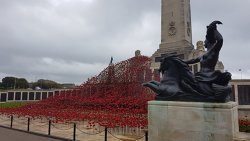
Naval War Memorial
Naval War Memorial
Unveiled in 1924, this memorial was one of three identical obelisks designed by Sir Peter Lorimer to commemorate sailors killed in the First World War. The other two can be found in Chatham and Portsmouth. Initially, the memorial held the names of 7,200 sailors. After the Second World War, it was extended by Sir Edward Maufe to include an additional 16,000 names.
Merchant Navy Memorial
The Merchant Navy Memorial, unveiled in 2019, is dedicated to the men and women of the British Merchant Navy and Fishing Fleets.
Merchant Navy Memorial Text
Merchant Navy Memorial
The Merchant Navy
Over the centuries, the peoples of the British Isles have depended on ships to carry cargo and passengers to and from all corners of the world.
In recognition of the sacrifice and effort expended in the First World War, King George V bestowed the title “The Merchant Navy” on the fleet. Ships of the British Merchant Navy fly a red or blue ensign and have civilian crews.
Seafarers have always faced the perils of the sea as they traversed the oceans using the power of the wind for many millennia until the advent of mechanical power. The skills of these sailors embraced the knowledge of wind, sea and tide together with the ability to navigate safely to their destinations. The potential dangers of shipboard life remain, requiring high standards of seamanship to ensure the safety of ships and their crews and for the protection of the marine environment.
In the wake of technological advances, ships have become larger, faster and more specialised, not only carrying cargo or passengers but also engaged in marine exploration and environmental research. Leisure time has increased leading to a growth in recreational sailing.
The Fishing Fleets
In our nation of islands, nobody is more than 75 miles from the sea. We have a long history of harvesting marine life for food and fertiliser. For many years, the consumption of fish was mandatory for religious reasons. Fishing also provided a rich source of trained seafarers. The ports of southwest England were and are at the forefront of supporting the fishing fleet.
The composition of the fleets and the skills sets provided by their crews, has changed over time. The advance of technology is a predominant influence that has been balanced by conservation measures to protect stocks from over-exploitation. Zonation of the world's oceans under the United Nations law of the sea conventions has also impacted fishing activity particularly that in distant waters.
The perils of the sea affects all seafarers but in fishing boats these dangers are magnified as the boats tend to be smaller and therefore more vulnerable than in many other types of vessel. The crew of a fishing boat is required to work on deck in all weather conditions further amplifying the exposure to harm.
In both world wars, the fleets played vital roles in supporting the nation by continuing to maintain a much-needed supply of fish protein. Additionally, they provided boats and crews for the hazardous duties of minesweeping and coastal defence.
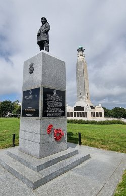
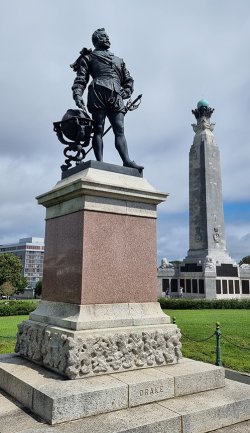
Drake's Statue
Drake's Statue
The statue of Sir Francis Drake was unveiled in 1884 to commemorate the 300th anniversary of the Spanish Armada.
The commemorations of the time reflected the Victorian view of Drake as a national hero. He was an adventurer and the first Englishman to circumnavigate the globe, and he was knighted in 1581. He served as mayor in Plymouth and oversaw the building of Drake's Leat, a 17-mile-long stone-lined channel that supplied drinking water from Dartmoor to Plymouth.
However, Drake was also a privateer with links to the slave trade. Raised by the Hawkins family of Plymouth, his older cousin, the slave trader John Hawkins, gave him work on various expeditions. These included voyages to Sierra Leone, where over 1,200 African people were enslaved, and many more were killed. To the Spanish, he was known as the pirate 'el Draque.'
In 1578, Drake captured a single Spanish ship, the Nuestra Senora de la Concepcion, laden with 25,000 pesos of Peruvian gold, his most famous prize. In 1587, he sailed to the Cadiz in Southern Spain and set alight the ships of the gathering Spanish forces before raiding forts along the Portuguese coast.
Then, in 1588, the Spanish Armada, a fleet consisting of 130 ships, sailed to invade England and overthrow Queen Elizabeth I. Drake sailed eight burning ships at the Spanish vessels, defeating the Armada.
Drake's Statue Text
Frances Drake sailed from Plymouth on December 13.1577, to begin the “famous voyage" during which he traversed the Strait of Magellan and discovered Drake's passage south of Cape Horn. Drake then sailed the Golden Hinde north and, in June 1579, landed in California; he took possession of that region for Queen Elizabeth, naming it Nova Albion. He returned to Plymouth on September 26, 1580, having circumnavigated the globe. Drake was knighted aboard the Golden Hinde at Deptford in the presence of Queen Elizabeth on April 4, 1581.
This plaque was presented on August 5, 1977, by the state of California's Sir Francis Drake Commission in commemoration of the quadricentennial of Drake's voyage around the world.
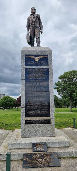
Royal Air Force Commonwealth and Allied Air Forces Monument
Unveiled in 1989, dedicated to those who lost their lives in the Second World War.
RAF Commonwealth and Allied Air Forces Monument Text
RAF Commonwealth and Allied Air Forces Monument
Royal Air Force Commonwealth & Allied Air Forces 1939 - 1945
Tribute To all men and women of Great Britain, Australia, Canada, India, New Zealand, Rhodesia, and South Africa. Belgium, Czechoslovakia, Denmark, France, Greece, the Netherlands, Norway and Poland. The United States of America, the Union of Soviet socialist republics & many other nations, who served in all commands of the Royal Air Force, Commonwealth and Allied Air Forces during the Second World War.
Their courage, skill, and devotion to duty was of the highest order. By winning the Battle of Britain, the men and women of fighter and other commands saved this country from invasion in 1940.
"Never in the field of human conflict has so much been owed by so many to so few" - Winston Churchill
Coastal command played a vital role in keeping the sea lanes open.
The commands in the Middle East, Africa and the Far East made great contributions towards final victory.
From the outbreak of war, the bomber offensive steadily increased, and after the formation of the Pathfinder group in 1942, very severe damage was inflicted on the enemy by the constant night and day operations carried out by bomber command and the United States Air Force.
Control of the skies over Europe in 1944 was a vital factor to the success of the Normandy landings. The combined efforts of tactical and bomber commands and the United States Air Force spearheaded the Allied advance across Europe.
The inspired leadership of Bennett, Dowding, Harris, Portal, Slessor, and Tedder of the Royal Air Force and Arnold, Eaker, and Spritz of the United States Air Force paved the way to victory in 1945.
"Now at last the bomber commands have won the air battle of Europe opening the path for victory and freedom for the enslaved countries of Europe" - Churchill 1945
Honour 107,000 members of the Royal Air Force. 84,000 members of the United States Air Force. 42,200 members of the Soviet Air Force. Who made the ultimate sacrifice.
They flew by day and night and gave their lives to keep forever bright that precious light, freedom.
Other significant memorials and statues on the Hoe
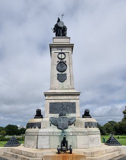
Armada Memorial
Armada Memorial: Built in 1888, 300 years after the defeat of the Spanish Armada. The figure on top is Britannia, representing Britain in human form.
Armed Forces Memorials: Memorials from World War Two and later conflicts, honouring various associations such as the Polish Navy Normandy Veterans Association, Falklands War, Dunkirk Veterans Association, Falklands Naval Forces, HMS Gloucester, British Korean War Veterans Association, 1st British Army, National Malaya and Borneo Veterans Association, Burma Star Association, and Aden Veterans.
Sir Francis Chichester Plaque: Commemorates Sir Francis Chichester's single-handed voyage around the globe.
Plymouth War Memorial: Remembers all those who lost their lives during the two world wars.
Boer War Memorial: Dedicated to those who lost their lives in the Boer War.
Smeaton's Tower
Smeaton's Tower was the third 'Eddystone Lighthouse' built on the Eddystone reef, 14 miles offshore from Plymouth. It was designed by John Smeaton, who modelled the lighthouse on an oak tree. Construction began in 1756, with stones of Cornish granite loaded onto a ship in Millbay and transported to the reef. The building work took three years and cost £40,000. Smeaton's Tower was in use from 1759 until 1877. The campaign for its removal began after it was described as unstable, reportedly 'swaying in the waves' during storms.
Smeaton's Tower
The original lighthouse was 22 meters high. It was taken down and rebuilt on Plymouth Hoe, with a four-meter tower base remaining on the reef. The first Eddystone lighthouse was Winstanley's Tower, built in 1696. The second was Rudyard's Tower, which lasted from 1708 until 1755, when it caught fire. One of the three lighthouse keepers, Henry Hall, was burned by molten lead falling from the roof, which hit his head, neck, and shoulders. Some even went down his throat, yet he survived several days despite being 94 years old. Smeaton's Tower was replaced by Douglas's Lighthouse, which is still in use today and can be seen on a clear day alongside the base of Smeaton's Tower.
Also on the Hoe
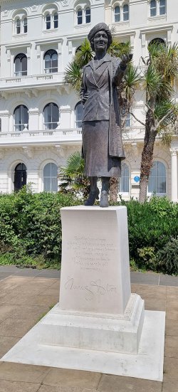
Lady Astor Statue
Norrington's Water Fountain: Presented to the town of Plymouth by former Mayor, Charles Norrington of Abbotsfield. In memory of his wife Marianne Norrington. Mrs. Norrington used to walk her children along the Hoe and was troubled by the lack of drinking water available for less fortunate children. Made of pink granite, the fountain provided water to the people of Plymouth until the 1970s, when concerns about water quality led to its closure.
The Viking Stone: To mark the 1,000th anniversary of the final Viking raid up the Tamar River, representatives from five Scandinavian nations gifted this stone to the City. It symbolizes the enduring friendship and goodwill between England and Scandinavia. Crafted by Danish sculptor Magnuss Krugh Anderssen, the Rhune stone was revealed in a ceremony attended by the Lord Mayor of Plymouth and Magnuss Magnusson, who delivered a speech recounting Viking history in Britain.
Elliot Terrace: These buildings were constructed in the 19th century as Plymouth's prosperity grew. Facing the sea, they were built specifically to enjoy the view. Elliot Terrace was built in 1860. Sir Arthur Conan Doyle, the author of Sherlock Holmes, lodged briefly at number 6. Number 3 Elliot Terrace was the residence of Lord and Lady Astor and was later gifted to the city.
Lady Astor Statue: Lady Nancy Astor was born in 1879 in Virginia. After moving to England in 1905, she married Waldorf Astor. When Waldorf inherited his father's seat in the House of Lords in 1919, he was forced to give up his seat in the House of Commons. His wife stood in his place as the Conservative representative and won the resulting by-election, just over a year after some women had won the right to vote.
She became the first woman to take her seat in the House of Commons. Nancy Astor was an unusual candidate: she was American, divorced, and not university-educated. However, she could hold an audience, was witty and intelligent, and had already done much work in Plymouth, including establishing maternity centres and creches. In 2019, the Nancy Astor statue was unveiled to mark one hundred years since she took her seat in the House of Commons.
The Royal Citadel: The Citadel dominates the foreshore and the approach to the harbour. It replaced an Elizabethan fort built in the 1590s in the wake of the Spanish Armada. Like the Citadel, the triangular Elizabethan fort stood on top of the Hoe, featuring earth walls and timber gun platforms along the foreshore.
These structures were near the present building, "Fisher's Nose", which juts out over the sea at the corner. Constructed in 1847 as a magazine or ammunition store with a guard house for the Citadel's outer defences, Fisher's Nose was originally attached to the main structure but was cut through when a road was constructed.
In 1796, the East India Company ship 'Dutton' ran aground here. With 400 soldiers and many women and children aboard, it smashed against the rocks under the Citadel. Thanks to the actions of a Royal Navy Captain, only 15 casualties occurred. This incident, among others, led to the construction of the breakwater to protect against the sea.
The Belvedere: Completed in 1891, the Belvedere is informally known as the 'wedding cake.' it is said to have been the site of a bull-baiting ring in the early 17th century. From this point, you can see the areas that surround Plymouth Sound. Looking out from left to right (east to west), you can see the following:
The River Plym opens out into the Sound from the east, in front of the Mount Batten peninsula.
Mount Batten Tower stands on a hill, and the Cattewater breakwater stretches out to protect the harbour.
Beyond that, you can spot Staddon Point Battery and Bovisand Fort, which were built after the breakwater was constructed to defend the eastern channel. The mile-long breakwater was completed in 1848. Designed by the engineer and bridge builder John Rennie, it took 37 years to build and is said to have used 4.5 million tons of stone.
Behind Drake's Island, you can see the Rame Peninsula in Cornwall. Mount Edgcumbe is on the nearest headland. Mount Edgcumbe House was initially built in the mid-16th century. Defences, including Picklecombe Fort, were also constructed to protect the western channel between the breakwater and Cornwall.
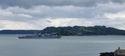
Devonport
HMS Iron Duke approaching Devonport
Historically known as Plymouth Dock, Devonport has been a substantial naval base since the 17th century. It became one of the Royal Navy's key dockyards, essential for shipbuilding and repairs. The Devonport Dockyard is still operational today, maintaining its significance for the Royal Navy.
The area has seen extensive redevelopment, blending historical architecture with modern housing and facilities. Devonport Park, one of Plymouth's largest green spaces, offers a relaxing environment with beautiful gardens, play areas, and sports facilities.
Royal William Yard
The Royal William Yard is a historic waterfront complex built in the early 19th century to provide victuals (provisions) for the Royal Navy. Designed by Sir John Rennie, the Yard is one of the most significant groups of historic military buildings in Britain.
After being decommissioned, the area underwent substantial regeneration and now houses a mix of apartments, restaurants, bars, and offices. The Yard retains its grand architectural features and offers stunning views over the Tamar River. It is also a cultural hub, hosting events, art installations, and markets throughout the year.
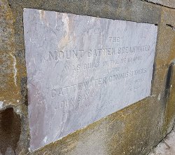
Mount Batten Breakwater
Mount Batten
Mount Batten, a peninsula named after Sir William Batten, a 17th-century English naval officer, offers a rich maritime history. It was once a bustling fishing community and later became a key defensive point during World War II. The prominent Mount Batten Tower, which dates back to the 17th century, was built to protect the Cattewater, the entrance to Plymouth Harbour.
Today, Mount Batten is a popular spot for water sports, with sailing, kayaking, and diving facilities. The area provides stunning views of Plymouth Sound and is a gateway to exploring the marine environment.
Sutton Harbour
Sutton Harbour, initially called Sutton Pool, was the site of a fishing village named 'Sutton' in the Middle Ages. The name 'Sutton' translates to 'South Town.'
During medieval times, the small town of Plymouth prospered through fishing, merchant shipping, and naval operations. In the 16th century, significant wealth was brought to Plymouth from fishing, as fishermen travelled as far as Newfoundland in search of cod. Trawling was introduced over two centuries later, and the advent of the railway facilitated swift transport to the London market, further boosting Plymouth's fishing industry.
In 1896, a new fish market was constructed on the harbour. This market was relocated to a different site on the far side of the harbour in 1995. Today, Plymouth remains a prominent fishing port, home to one of the largest fish markets in England.
The towns of Plymouth, Devonport, and East Stonehouse formally merged in 1914 to form the Borough of Plymouth. Fourteen years later, in 1928, Plymouth successfully petitioned for city status, which was granted by the King.
Originally developed as a victualling yard, the Eastern side of the harbour housed the Victorian Emigration Depot between 1840 and 1900. During this period, over 370,000 people departed from Plymouth to Australia and New Zealand, with most being official emigrants benefitting from free or assisted passage. These passages were funded by colonial governments through the sale of land, which was often seized or purchased at low cost from indigenous populations.
Emigration was encouraged by British and colonial governments, entrepreneurs, social reformers, and churches as a means to address unemployment and poverty in Britain while providing much-needed labour for the colonies. Approximately half of the emigrants who left Plymouth were from the southwest of England, and a third were from Ireland. The potato famine in Ireland and the discovery of gold in Australia and New Zealand contributed to the rise in emigration during this period.
The Emigration Depot was particularly busy between 1876 and 1886, when an agricultural depression and the collapse of Cornish mining led to falling wages and widespread unemployment. Some of the assisted emigrants were paupers, and workhouse orphans sent overseas to work as domestic servants. The depot was demolished in 1937 to make way for the construction of Madeira Road. Today, only one building and one pier remain from the original Depot.
Sutton Harbour Plaques
Plymouth men who helped to found modern Australia
Captain Tobias FURNEAUX charted the coast of Tasmania, and in 1773 became the first Englishman to land there. Captain John MACARTHUR gave Australia prosperity through his introduction of merino sheep in the 1790s. Captain William BLIGH survived the mutiny aboard the Bounty to become Governor of New South Wales 1806-1809. Colonel George ARTHUR was Lieutenant Governor of Tasmania 1823-1836. Major Edmund LOCKYER raised the British flag in Western Australia in 1827. Both Furneaux and Bligh accompanied Captain James Cook on the second of his three great voyages of discovery, all of which left from Plymouth. 1768, 1772. and 1776.
From Plymouth on 13th March 1787, sailed the transport ships 'Friendship' and 'Charlotte' carrying men and women convicts bound for Australia.
On 26th January 1788, with nine other ships from England, they landed at Port Jackson, which became Sydney, New South Wales. There, they established the first British colony under the command of Captain Arthur Phillip R. N., The father of modern Australia.
This plaque commemorates the of the six Plymouth company vessels carrying settlers from Cornwall. Devon and Dorset to establish the settlement of New Plymouth in the colony of New Zealand.
WILLIAM BRYAN - 312 TONS - SAILED 19 NOVEMBER.1840
AMELIA THOMPSON - 477 TONS - SAILED 25 MARCH 1841
ORIENTAL - 506 TONS - SAILED 2 JUNE - 1841
TIMANDRA - 382 TONS - SAILED 2 NOVEMBER 1841
BLENHEIM - 374 TONS - SAILED 2 JULY 1842
ESSEX - 329 TON - SAILED 3 SEPTEMBER 1842
Napoleon in Plymouth
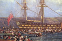
HMS Bellerophon in Plymouth Sound
Napoleon, Emperor of the French, surrendered to the Royal Navy shortly after his defeat at the Battle of Waterloo. While British authorities deliberated his fate, Napoleon was detained aboard HMS Bellerophon in Plymouth Sound for nearly ten days. It was during this time that he learned he would be exiled to the South Atlantic island of St Helena.
News of Napoleon's presence spread rapidly, prompting many people to seek a glimpse of the man they had been at war with for so many years. Crowds gathered along the shores overlooking the Sound, and some hired boats to row closer to the ship. This created a vibrant and colourful scene as many spectators wore their best attire. Napoleon could occasionally be seen through his stern cabin window, but his regular daily appearances on deck provided a better view.
Visitors flocked from across Devon and Cornwall, with some travelling from as far as Dorset and even London. The boatmen of Plymouth benefited greatly from this surge in visitors, with 8,000 people reportedly afloat in the Sound on July 30, 1815. Despite the excitement and large crowds, the only casualty was John Boynes, a stonemason at the Plymouth Dockyard, who drowned in a boat collision.
Naval Orders on Napoleon's arrival in Plymouth Sound
Naval Orders on Napoleon's arrival in Plymouth Sound
"The 'Liffey' and 'Eurotas' are to take up an anchorage on each side of the 'Bellerophon', at a convenient distance, and observe the following directions, as well for the purpose of preventing the escape of Buonaparte, or any of his suite, from that ship, and for restraining shore-boats and others from approaching too close to her, either from curiosity or any other motive.
No shore-boats, or others, are to be suffered, either by night or by day, to approach nearer the 'Bellerophon' than one cable's length, and no boats are to be permitted to loiter about the ship, even at that distance, either from curiosity or any other motive."
Admiral Lord Keith, Commander in Chief, Channel Fleet, Plymouth
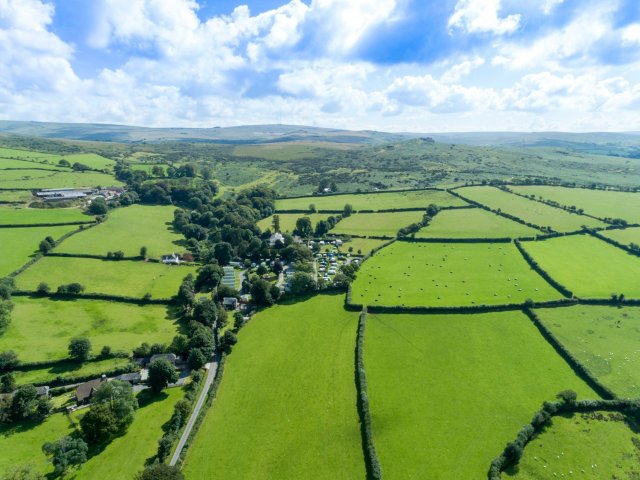
Situated on the southwest edge of Dartmoor, this holiday park has been developed on the grounds of the old Langstone Manor house. The touring pitches are tucked into various garden areas with mature trees and flowering shrubs or in the walled garden area with views over the moor. There are 40 level grass pitches, which vary in size (35 with 16A electricity). A popular camping area has been terraced with open views over farmland and the moor.
Parkland is in an area of outstanding natural beauty and ideally situated for exploring all the stunning South Hams area of South Devon has to offer. Open all year, the site is set within three acres of mature, landscaped grounds with panoramic views over Kingsbridge and Salcombe and the rolling countryside towards Dartmoor National Park.
Modbury Caravan and Motorhome Club site is situated within easy distance to the ancient village of Modbury. Nestled cosily between the moors and the sea, it is the perfect base from which to explore the charming surrounds of South Devon. The site offers you the pleasant choice between the quiet and solitude of beautiful Dartmoor with its tumbling streams, historic landscapes and lush views or the many small villages that make up the pleasantly rural South Hams. The site has 114 grass/hardstanding pitches (some seasonal) all with electricity 16amp. No arrivals before 1.00pm.
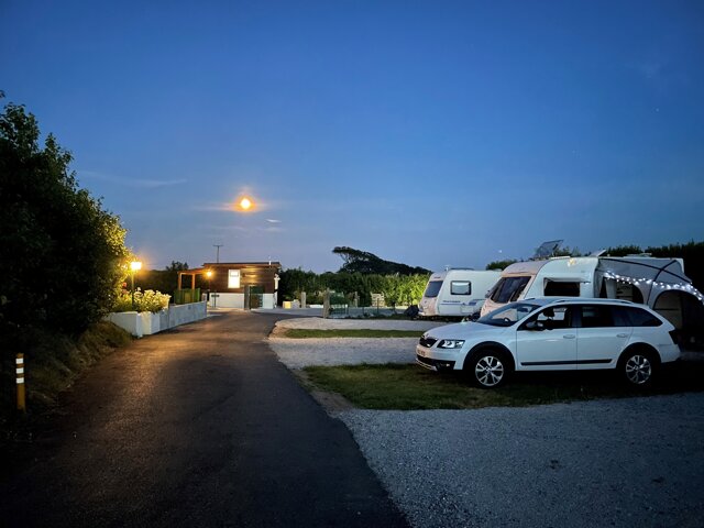
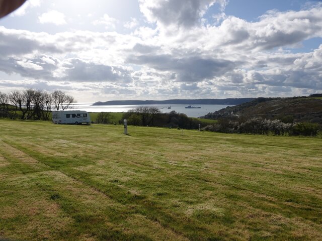
Plymouth Sound Caravan and Motorhome Club site rests on a headland outside the town of Plymouth and offers superb views across the glorious Sound. This delightful site is close to the South West Coastal Footpath for unforgettable walks, the Plym Valley Cycleway for those keen to experience some wonderful scenery by bike and many lovely beaches. The site has 62 grass pitches (some seasonal) all with electricity 16amp. No arrivals before 1.00pm.
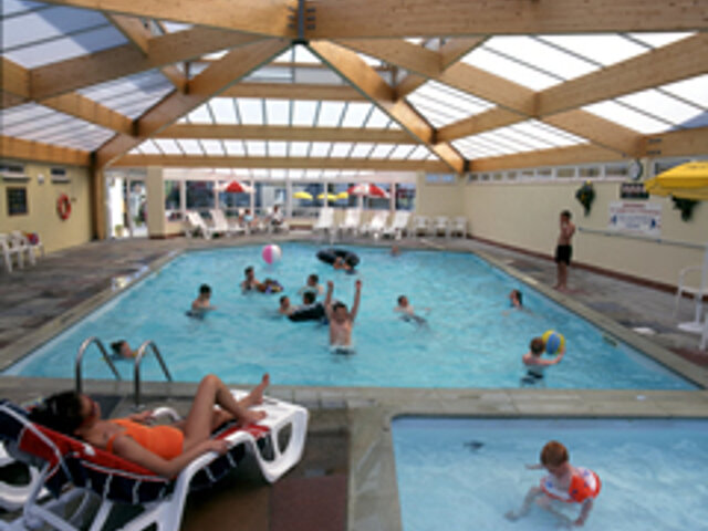
Whitsand Bay is in a stunning location on the clifftops of the Rame Peninsula in southeast Cornwall. The views stretch 30 miles in all directions. A range of accommodation is on offer, from luxury holiday lodges through to basic, no-frills chalets, and fully serviced pitches for caravans and motor homes to simple grass pitches for small tents. This is an Area of Outstanding Natural Beauty (AONB) renowned for its long, golden beaches. Open all year round, the park facilities include a heated indoor swimming pool, a shop and café and a cosy bar/restaurant in what was the Warrant Officers’ Mess in the days when it was home to Whitsand Bay Battery.
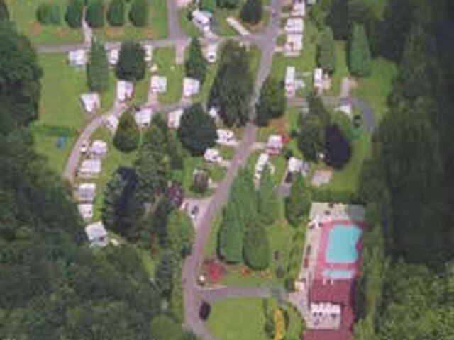
As you leave the A38 for Plymouth, negotiate the Marsh Mills roundabout and approach through a light industrial estate, you can have no idea that there is a lush green touring park tucked away from the modern, out-of-town shopping units in a quiet green valley. Part of the park is being developed to provide a residential area alongside the River Plym which has therefore meant a reduction in the number of touring pitches. However, there are still some 200 spaces available for touring, 130 of which have 10A electricity, and 65 are on hardstanding. There are also 59 grass pitches for tents. Hidden behind a high, evergreen hedge are an attractive swimming pool and children’s pool. A play area is nearby and a pleasant restaurant with a bar and games room provide welcome facilities and entertainment in high season.
Rob has been involved in the leisure industry since completing a BTEC in Travel & Tourism in 1993. Previous roles have included the promotion of tourism in Yorkshire and running a motorcycle touring company in the Australian Outback.
He is the General Manager at Alan Rogers Travel Group, responsible for the ongoing development of the Alan Rogers website and the publication of the Alan Rogers Guides and 'Destinations' magazine.
Rob has owned several caravans, and he regularly travels with his wife and young daughter in their VW Transporter, complete with a Tentbox roof tent. A keen cycling fan, Rob can often be found in a field in Belgium during the 'Spring Classics' season.
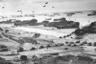
The 6th of June 2024 will mark the 80th anniversary of D-Day, an opportune time to reflect on the historic events that unfolded along the Normandy coast in the days that followed.
France has been shaped over the centuries by countless events. Some well documented, others less immediately obvious. But all played a part in creating a France that we know and love today.
The beaches of Normandy saw the largest seaborne invasion in history - 6th June 1944 or D-Day marked the beginning of the Allied campaign to wrestle occupied Europe from Nazi control