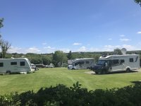
West Runton Camping & Caravanning Club Site
England, East of England, Norfolk, Cromer
- Tel:
- +44 1263 837544
- Open:
- Early April-Early November
Alan Rogers Review of West Runton Camping & Caravanning Club Site
You can get a feel for the varied Norfolk coast and countryside from West Runton Camping & Caravanning Club Site; it commands a secluded location close to the quaint seaside village with which it shares its name. A short walk from the site brings you to the quaint fishing village of West Runton. Its sandy beach is perfect for sunbathing while the plentiful rock pools are waiting to be explored. For more sandy beaches, piers and promenades, Sheringham, Cromer (both within walking distance of the site) and Caister-on-Sea are worth visiting. A mile south of West Runton, Beacon Hill is the highest point in Norfolk. Scale the dizzy height of 300ft, and you will be rewarded with views over the countryside and coast. The site has 180 grass and hardstanding pitches (some seasonal), most with an electric hook-up point. There are also 5 Safari tents available to hire.
Non-members are welcome and may join on-site. Please speak to site staff for details and to check pitch availability before arrival.
For nature lovers, Blakeney Point is a must. This mix of dune, marsh and shingle is home to seals and a variety of birds. Catch a ferry from Mortson Quay to see them. There are more animals to be seen at the Hillside Shire Horse Sanctuary and the Norfolk Shire Horse Centre close to the site.
Facilities at West Runton Camping & Caravanning Club Site
The site has 2 toilet blocks that provide showers, washbasins & WC’s. Accessible sanitary facilities, Parent and child room. Laundry. Dishwashing area. Motorhome service point. Children’s play area. Ball games area. Pets welcome. Dog walk. No Wi-Fi. Information area. Gas sales. Ice pack freezer. Caravan & motorhome storage. 2 Boules pitches. Beach 1 mile. Bus stop 0.7miles. train station 0.75 miles. Earliest arrival time 13.00.
Directions to West Runton Camping & Caravanning Club Site
From King’s Lynn on A145 turn left at Roman Camp Inn into Sandy Lane. Site entry track (½mile long) is at the crest of hill turn right opposite National Trust Sign. Difficult access via rough surfaced lane through woods to improve vision ahead use passing places.
| Postcode | Latitude, Longitude | what3words (What is this?) | Directions (from your current location) |
|---|---|---|---|
| Postcode: NR27 9NW | Latitude, Longitude: 52.929353, 1.254648 | ///enrolling.successor.swarm | Directions To Campsite Via Google Maps |
Campsite Google Map
The following consent is required:
Tracking & performance, Targeting & advertising.
Campsites Near-by
Other Campsites From The Camping and Caravanning Club


